Property Record
345 Scarlet Rd, Kennett Square, PA 19348


Save to a Folder
{{folder.Name}}
{{folder.ListingIds.length}} Properties
{{folder.ListingIds.length}} Property
Create a New Folder
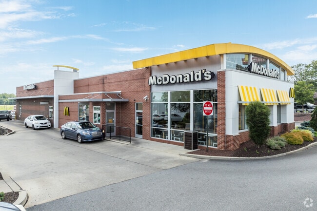
Property Detail
345 Scarlet Rd
60-002-0097.01A0
1.3 AC & RESTAURANT LOT 1
Commercialnec
Chester
CI
Pennsylvania
B and X Area of moderate flood hazard, usually the area between the limits of the 100-year and 500-year floods.
1
2026
1.34 AC
2026
Outer Chester County
306503
Philadelphia
8,040 SF
Philadelphia-Camden-Wilmington, PA-NJ-DE-MD
NEARBY LISTINGS FOR SALE OR LEASE
DEMOGRAPHICS near 345 Scarlet Rd
1 mile
3 mile
5 mile
2025 Total Population
6,003
22,918
51,383
2030 Population
6,257
23,675
52,849
Pop Growth 2025-2030
+ 4.23%
+ 3.30%
+ 2.85%
Average Age
39
40
43
2025 Total Households
2,086
7,895
18,213
HH Growth 2025-2030
+ 4.36%
+ 3.46%
+ 3.03%
Median Household Inc
$101,832
$118,523
$140,725
Avg Household Size
2.80
2.80
2.70
2025 Avg HH Vehicles
2.00
2.00
2.00
Median Home Value
$454,285
$552,449
$596,887
Median Year Built
1979
1985
1987
Nearby Places
Map Layers
Map Styles
 Street
 Aerial
Layers
 Traffic
 Biking
Places
Listings with unknown addresses are not visible on the map
- Restaurants
- Banks
- Shops
- Fitness
- Groceries
PUBLIC TRANSPORTATION
AIRPORT
Wilmington Airport
Drive
Walk
Distance
Wilmington Airport
32 min
17.7 mi
Philadelphia International
Drive
Walk
Distance
Philadelphia International
48 min
28.5 mi
Freight Ports
Port of Wilmington, RI
Drive
Walk
Distance
Port of Wilmington, RI
36 min
21.1 mi
Nearby Properties
Address
Land Use
TOTAL SIZE
Lot Size
Zoning
Address
Land Use
TOTAL SIZE
Lot Size
Zoning
387,796 SF
41.80 AC
ES1
Address
Land Use
TOTAL SIZE
Lot Size
Zoning
215,130 SF
11.80 AC
R2
Address
Land Use
TOTAL SIZE
Lot Size
Zoning
144,384 SF
25.30 AC
HC
Address
Land Use
TOTAL SIZE
Lot Size
Zoning
238,215 SF
35.70 AC
R3
Address
Land Use
TOTAL SIZE
Lot Size
Zoning
105,405 SF
17 AC
R1
Address
Land Use
TOTAL SIZE
Lot Size
Zoning
159,484 SF
22.01 AC
HC
Address
Land Use
TOTAL SIZE
Lot Size
Zoning
129,278 SF
14.98 AC
R2
Address
Land Use
TOTAL SIZE
Lot Size
Zoning
121,326 SF
14.98 AC
R2
Address
Land Use
TOTAL SIZE
Lot Size
Zoning
152,629 SF
152.30 AC
ES1
Address
Land Use
TOTAL SIZE
Lot Size
Zoning
99,564 SF
0.62 AC
C2
Address
Land Use
TOTAL SIZE
Lot Size
Zoning
67,011 SF
6.78 AC
R2A
Address
Land Use
TOTAL SIZE
Lot Size
Zoning
451,182 SF
94.70 AC
BP
Address
Land Use
TOTAL SIZE
Lot Size
Zoning
114,126 SF
18.10 AC
CI
Address
Land Use
TOTAL SIZE
Lot Size
Zoning
67,244 SF
9.50 AC
MU
Address
Land Use
TOTAL SIZE
Lot Size
Zoning
69,351 SF
25 AC
UD
Address
Land Use
TOTAL SIZE
Lot Size
Zoning
59,836 SF
6.33 AC
R2
Address
Land Use
TOTAL SIZE
Lot Size
Zoning
79,272 SF
0.79 AC
C2
Address
Land Use
TOTAL SIZE
Lot Size
Zoning
75,610 SF
16.26 AC
R2
Address
Land Use
TOTAL SIZE
Lot Size
Zoning
138,738 SF
11.40 AC
CI
Address
Land Use
TOTAL SIZE
Lot Size
Zoning
200,337 SF
14 AC
CI
Address
Land Use
TOTAL SIZE
Lot Size
Zoning
53,134 SF
1.76 AC
R2
Address
Land Use
TOTAL SIZE
Lot Size
Zoning
70,197 SF
64.54 AC
ES1
Address
Land Use
TOTAL SIZE
Lot Size
Zoning
60,936 SF
3.53 AC
R2
Address
Land Use
TOTAL SIZE
Lot Size
Zoning
65,310 SF
5.07 AC
RB
Address
Land Use
TOTAL SIZE
Lot Size
Zoning
114,904 SF
10.40 AC
CI
Address
Land Use
TOTAL SIZE
Lot Size
Zoning
17,781 SF
6.70 AC
MU
Address
Land Use
TOTAL SIZE
Lot Size
Zoning
175,250 SF
50 AC
SA
Address
Land Use
TOTAL SIZE
Lot Size
Zoning
106,210 SF
11.70 AC
UD
Address
Land Use
TOTAL SIZE
Lot Size
Zoning
54,097 SF
3.80 AC
R3
Address
Land Use
TOTAL SIZE
Lot Size
Zoning
46,364 SF
2.15 AC
RB
The World's #1 Commercial Real Estate Marketplace
Connect with us
© 2026 CoStar Group
The information above has been obtained from sources believed reliable. While we do not doubt its accuracy we have not verified it and make no guarantee, warranty or representation about it. It is your responsibility to independently confirm its accuracy and completeness. Any projections, opinions, assumptions, or estimates used are for example only and do not represent the current or future performance of the property. The value of this transaction to you depends on tax and other factors which should be evaluated by your tax, financial, and legal advisors. You and your advisors should conduct a careful, independent investigation of the property to determine to your satisfaction the suitability of the property for your needs.